Lata Kijang Waterfall: A Step-by-Step Guide
Lata Kijang Waterfall, Jelebu, Negeri Sembilan
Date visited: 21 January 2018 (Sunday)
Date visited: 21 January 2018 (Sunday)
Vehicle: Preferably 4WD
Duration of drive: 20 minutes drive from guardhouse to the waterfall. Possible to hike up from there.
Duration of drive: 20 minutes drive from guardhouse to the waterfall. Possible to hike up from there.

Getting There
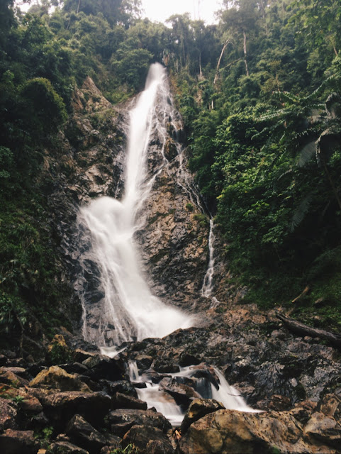
Not to be confused with Lata Kinjang Waterfall in Perak, Lata Kijang Waterfall is located some distance off the Selangor-Negeri Sembilan border, and it is the tallest waterfall in Negeri Sembilan.
This GPS location aims to direct you to the entrance of a forest reserve guardhouse, where you'll arrive at the waterfall in another 20 minutes drive.
Along the way here, you might come across many cyclists. The road will become narrower, but it is still well-maintained. Moving forward, you'll find yourself passing by a few kampungs before reaching.
We parked our cars in front of Balai Raya Kampung Tohor, hopped on our 4WD and continued on.
Following this GPS location, you'll soon arrive at a part where the GPS directs you across a river at the final few metres before your destination. The path across the river doesn't lead you to the waterfall, so go straight instead. As you go in further, the road condition gets bumpier. The road is tarred, but with plenty of holes.
Just another one-minute drive, you'll reach the Kenaboi Forest Reserve guardhouse (you can turn off your GPS once you're here). After this guardhouse, you'll need another 20 minutes drive ahead to reach the waterfall.
This GPS location aims to direct you to the entrance of a forest reserve guardhouse, where you'll arrive at the waterfall in another 20 minutes drive.
Along the way here, you might come across many cyclists. The road will become narrower, but it is still well-maintained. Moving forward, you'll find yourself passing by a few kampungs before reaching.
We parked our cars in front of Balai Raya Kampung Tohor, hopped on our 4WD and continued on.
 |
| Go straight and you'll see a river on your left. |
Following this GPS location, you'll soon arrive at a part where the GPS directs you across a river at the final few metres before your destination. The path across the river doesn't lead you to the waterfall, so go straight instead. As you go in further, the road condition gets bumpier. The road is tarred, but with plenty of holes.
 |
| The blue strip part is where the river is, so when you arrive at that red point, just go straight. |
 |
| On the other side of the river is a campsite. |
Just another one-minute drive, you'll reach the Kenaboi Forest Reserve guardhouse (you can turn off your GPS once you're here). After this guardhouse, you'll need another 20 minutes drive ahead to reach the waterfall.
 |
| The entrance. |
The road condition after the guardhouse was quite bad, with plenty of potholes. The ride is going to be bumpy. If you're driving, go slow!
There will be a junction at one point, the steep path on your right leads to Gunung Besar Hantu, the left path will lead you to the waterfall.
You'll soon arrive at a flight of stairs and that's where you stop your car. Be extra careful at this part, as you might not be able to see the stairs from your point of view if you're driving.
Hike
There will be a junction at one point, the steep path on your right leads to Gunung Besar Hantu, the left path will lead you to the waterfall.
 |
| Take the path on your left. |
You'll soon arrive at a flight of stairs and that's where you stop your car. Be extra careful at this part, as you might not be able to see the stairs from your point of view if you're driving.
 |
| Reaching in 1 more minute! |
Hike
The only part you need to 'hike' is just a few flights of stairs down, and you can already see the waterfall. If you choose to hike from the guardhouse, it'll probably take you about an hour to reach.
Overview
Trail: Tarred, but be aware of potholes.
Precaution:
1. We were told not to get too close to the waterfall as accident had happened, where a falling stone hit someone in the head.
2. No leeches were spotted.
3. Overgrown tree branches above your head.
4. Broken stairs.
3. Overgrown tree branches above your head.
4. Broken stairs.
Waterfall: The water was not that cold on the day we went, quite a number of slippery stones, pools were quite shallow.
Good Photo-taking Spots:
1. Near the base of the waterfall
Nearby waterfall you can visit:
1. Jeram Toi Waterfall (https://goo.gl/maps/9miF6StaST32)
Video
Here's a video of us at Lata Kijang.
Personal Experience
On our way from KL to Lata Kijang, we were driving mostly on single lane roads, which is a popular cycling spot for many. Finding the guardhouse wasn't difficult, the GPS does most of the job.
The highlight of this trip, was that we drove more than 2-hours till the guardhouse, only to be told that we need a permit to enter. We tried our best to bargain with the guards but they resisted.
Then we thought of finding another trail to the waterfall. We went back to the junction (the red colour point) and crossed the river. The orang asli there told us there is no way of going to the waterfall from that particular area, it's just a camp site.
The two orang aslis were very very kind to help us, they followed us to the guardhouse and had a talk with the guards. In the end, they agree to let us through given that we return in 2 hours. I guess that their main concern was unpredictable accidents that would bring a lot of trouble for them.
When we were at the waterfall, the view totally took our breathe away! All the troubles we faced at the guardhouse - gone with the wind. It drizzled a bit while we were there, but it was over in a minute.
An orang asli who brought his family over for a dip told us that if the waterfall is turning yellow, it simply means that it is raining upstream and it's time to leave. He also said that the water level will get very high if it rains.
Just an extra info, you can visit Pekan Titi (https://goo.gl/maps/Mr5ccNYZNc92), a nearby town to get petrol and refreshments.
For those who wish to visit Lata Kijang, if you want a smooth ride in, it's probably best you get a permit beforehand. But you can always try your luck finding orang aslis to help you. We wish you good luck!
Info On Hiking Permit
Here's what we got from our research online:
Where to get a permit?
Jabatan Perhutanan Negeri Sembilan (JPNNS)
Website: http://forestry.ns.gov.my/index.php/my/
Where is it located?
There are several JPNNS office branches across Negeri Sembilan, the nearest office from Lata Kijang waterfall is in Kuala Klawang, Jelebu, namely Pejabat Renjer Hutan Daerah Jelebu Kuala Klawang.
Location: https://goo.gl/maps/Hjh5ZLALvKz
This blog has a photo of the Jelebu office, you can refer it here:
http://mchiker.blogspot.my/2018/01/gunung-besar-hantu-kampong-ulu-kenaboi.html
You can opt to visit other JPNNS branches as well.
Website: http://forestry.ns.gov.my/index.php/my/hubungi-kami/peta-lokasi
Their operation time?
8am to 5pm on weekdays only.
Permit cost?
RM5 per person.

Comments
Post a Comment